Sediment Analysis
When sediments don’t get suspended, they keep adding layers upon layers at the bottom.
Storms Influence on Sedimentation
Remember a time when you looked at a river. Did you notice the clay particles that get moved by water and go downstream? Those little pieces of eroded soil are called sediment.
Effects of Sediments on Rivers
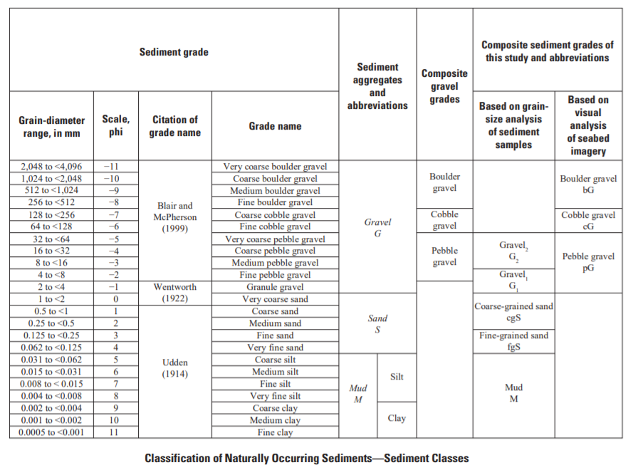
To build out a dredging and pumping system sediment characterization is done. Naturally occurring sediments contain various amounts of the aggregates mud, sand, and gravel. The separation of naturally occurring sediments into sediment classes, based on grain-size analysis, requires that limits be set on the amount of mud, sand, and gravel each class contains.
Classification of Naturally Occurring Sediments
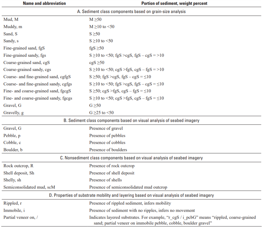
Guidelines for naming and abbreviating the components of sediment and non-sediment classes and the properties of substrates.
A sediment class, as determined by grain-size analysis, contains one or more of the components listed in A below. For example, a muddy, gravelly coarse grained sand (mgcgS) is a sediment class containing three components, mud, gravel, and coarse-grained sand, listed in order of increasing weight percent. A sediment class, as determined by visual analysis of seabed imagery, contains components listed in B below. For example, a pebble cobble gravel (pcG) is a sediment class consisting of pebbles and cobbles, not listed in order of increasing abundance. A non-sediment class listed in C below is a shell deposit, or an outcrop of rock or semi-consolidated mud. An unlayered substrate contains one sediment class (for example, muddy, fine-grained sand; mfgS) or a non-sediment class (for example, rock outcrop; R). Substrate mobility and layering properties are listed in D below. Layered substrates contain at least two sediment classes or a sediment class and a non-sediment class (for example, a rippled, coarse-grained sand partial veneer on immobile, semi-consolidated mud (r_cgS / i_scM). See figure 5 and tables 6, 7, and 9 for a summary of sediment and non-sediment classes. <, less than; >, greater than; ≤, less than or equal to; ≥, greater than or equal to.
Sources of Sediments and Sediment Contamination
Maintenance dredging of navigation channels does not create sediments. Sediments are the product of the natural processes of soil erosion, transport and sedimentation. Within any watershed, human activities may alter these processes in several ways. Agricultural and forestry practices can increase soil erosion. These land uses, along with urbanization can alter the overall hydrology of the watershed, changing the flow patterns in streams and rivers. Changes to flows along with modifications to stream and river channel morphology can alter the patterns of erosion ad deposition in these channels.
Fluvial sediments are those that are carried by rivers and streams. Deepened navigation channels and maintenance dredging interrupt the natural flow of fluvial sediments into the Great Lakes. Much of the human development around the Great Lakes was centered at ports and harbors located at the mouths of rivers. In many cases, the natural river channel was deepened as much as twenty feet. Sediments carried by the river are more prone to settle to the bottom in this deepened channel where river currents are slower.
Another type of sediment is fine-grained sand. The natural movement of these sands along the shoreline is called littoral drift. These sandy sediments deposit in deepened channels and harbors that extend into lakes.
Dredging does not create sediment contamination. The physical characteristics of sediments vary depending on the source of the sediments, properties of soil in the watershed, and the hydraulics of the waterway. The chemical characteristics of sediments will also vary, depending on the characteristics of the watershed, the presence, type and number of contaminant sources, including:
• urban and agricultural runoff;
• sewer overflows/bypassing;
• industrial and municipal wastewater discharges;
• landfill leachate/groundwater discharges; • spills of oil or chemicals;
• illegal discharges;
• air deposition;
• biological production, and;
• naturally occurring mineral deposits.
The rate of deposition of sediments in deepened navigation channels can be mitigated by controlling sediments at the source through soil conservation practices, protection and restoration of wetlands, and measures to alleviate streambank and shoreline erosion. The levels of contamination in sediments can also be reduced through point- and non-point source pollution prevention and remediation of in-place contaminated sediment deposits.
Reductions in discharge of sediments and pollutants in rivers and tributaries should include wastewater treatment upgrades, separation of combined sewer systems, air pollution controls, soil conservation and non-point pollution prevention. Efforts will result in reductions of contaminant levels found in the sediments. At most harbors, sediments dredged today are significantly cleaner than those dredged twenty or thirty years ago. However, there exists a substantial lag in time between the implementation of source controls and the appearance of cleaner sediments. This is caused by the reservoir of contaminants in sediments already in the waterway that are slowly migrating downstream. Consequently, the need to dredge and manage contaminated sediments should continue over the long term for best results.
Farming and Sediments
In farming regions, sediment sources include erosion from sheet and rill flow, gully development, and enlargement of drainage ditches. Agricultural fields in watersheds have extensive networks of subsurface and surface drainage. Intakes to drainage tiles are another sediment source and the increased runoff rates promoted by artificial drainage can increase erosion from flow through watershed networks.
Hill Topography Contributions to Sediments
Tall hillslopes, or bluffs near rivers or tributaries can be a large source of sediments. . Bluffs can be very large, more than 50m in height and 100s of min length along the stream. Bluff erosion is driven by river erosion at the toe, which triggers slope failure by grain fall, slumping, gullying, and block fall. The rate of bluff erosion is also influenced by the layering of material properties such as strength, hydraulic conductivity, and grain size, the orientation of the bluff, and the amount of groundwater supply which can determine seepage paths and pressures near the surface of the bluff. Bluffs that contribute the most sediment to the river are tall, wet, actively undercut by the stream, bare of vegetation, and composed of weaker sediment layers.
Bluff Erosion and Sediments
Control of bluff erosion ultimately requires protection of the slope toe against future erosion and retreat. Bluffs can continue to erode and supply sediment to the river for decades after toe protection; drainage control and slope revegetation are important factors in limiting further erosion. In developing a sediment budget to estimate the overall contribution from bluffs, the challenges are to determine the rates of bluff erosion and their controls, to identify all actively eroding bluffs, and to develop a reliable means of assigning erosion rates to all bluffs in the watershed.
Ravines Contributions to Sediments
Small steep valleys, termed ravines, cut through the bluffs, connecting the broad, flat uplands to the incised river channel below. Ravines vary widely in size, shape, relief, and proximity rivers. Unlike bluffs, ravines erode by a combination of hillslope and river processes. Although net erosional, ravines can store as well as erode sediment. Ravines exhibit a close coupling between hillslope and channel processes: incision of the channel in the bottom of the ravine triggers slope erosion by grain fall and slumping. Although the ultimate cause of ravines is the drop in elevation between the uplands and the incised mainstem channel, the immediate driver of erosion is the volume and rate of water discharged to the ravine, which can be increased by discharge from upland drainage systems. At their upper end, ravines may have sharp vertical cliffs or gentler forested hillslopes. Ravine channels can grade into smaller features termed gullies, which serve as the upper end of the ravine channel and are often controlled by grade and bank control measures. Some larger ravines store large quantities of sediment in the valley bottom. Under conditions of increasing water discharge, such ravines may shift from storing to releasing sediment and may become some of the largest individual sources of sediments.
Steambank Erosion
Streambank erosion supplies sediment directly into the river, although the net contribution of sediment from streambanks and the floodplains behind them is not easily apparent. The net sediment contribution depends on the balance between streambank erosion and sediment deposition along the river’s edge and on the floodplains adjacent to the river. This compensating deposition is too often neglected in determining the sediment budget of a valley bottom. The net sediment contribution from channel migration will be the balance between the volume eroded on one side and volume deposited on the other side. There may also be differences in grain size between eroding and depositing banks. The overall sediment balance for the valley bottom must also include deposition of sediment on the floodplains.
Methods to Track and Calculate Sediments
- Stream gauging
- Local measurement of sediment erosion and storage
- Sediment fingerprinting
- Sediment budgets
Stream gauging
Stream gauges generally consist of two separate operations. One involves periodic measurements of the rate of water flow, or discharge, and the river water level. From this information, a relationship between water level and discharge is developed and
a continuous record of water level record is used to provide a continuous estimate of water discharge. The second operation involves the periodic sampling of suspended solids. The relation between total suspended solids (TSS) and water discharge is developed and the continuous flow record is then used
to estimate the TSS load over the period of record. Stream gauges on tributaries should generally be operated when the ground is not frozen if your area freezes in spring through fall then removed during winter. The TSS loads are therefore seasonal, although little transport is presumed to occur during frozen conditions in the winter.
The gauge network identifies the total amount of sediment carried by the mainstem river as well as sediment contributions from the principal sub-watersheds. Although gauging provides a measure of the amount of sediment passing a river station, it cannot provide information about individual sources. However, in seven tributary watersheds, multiple gauges are operated with gauges above and below the incised lower parts of the river valleys. Comparison of the loads at the upstream and downstream gauges help to not only isolate the amount of sediment produced in these steepened parts of the watershed but also provides a constraint on the sediment produced by the abundant bluffs and ravines found in these locations.
Local measurement of sediment erosion and storage
Erosion at local sites can be measured through direct surveys or by changes measured on aerial photographs taken at different times. Field measurements of erosion, particularly in ravines and bluffs, allow contributions from individual sources to be determined. Because such erosion rates vary strongly in time (one large event might move more sediment than the total over many years), it can be difficult to reliably extrapolate local erosion rates to longer time periods. Comparison of air photos taken at different times allows erosion to be measured over longer time periods, but generally with less precision than local measurements in the field. For both bluffs and ravines, erosion rates vary widely from place to place as a function of a range of factors, so a basis for extrapolating measured rates to larger areas is needed. Because many factors control the rate of erosion, it is important to constrain these extrapolations with other evidence, particularly from gauge records and geochemical
fingerprinting.
Sediment fingerprinting
In recent decades, “radiometric fingerprints” and other geochemical tracers associated with sediment have been used to separate overland (field) erosion from non-field erosion (stream banks, bluffs, ravines, gullies) (Walling and Woodward, 1992, He and Owens,1995; Collins et al. 1997; Schottler and Engstrom, 2002). Atmospheric deposition of radioisotopes such as 210Pb and 137Cs enrich soils at the earth’s surface. When eroded, these materials carry a radiometric “fingerprint”, whereas sediments derived from deeper materials, such as by erosion of bluffs and ravines, have minimal exposure to atmospheric inputs and are thus depleted in these tracers. Comparing the tracer signature of field and non-field sources with the signature of suspended sediment in rivers permits the contribution of each
erosion source to be calculated.
TSS samples and sediment cores from fluvial depositional areas (backwaters, reservoirs, floodplain ponds) along major tributaries and the main-stem of the Minnesota River have been collected and analyzed for radioisotope tracers. TSS samples provide an event based measure of source apportionment, whereas core samples can provide a signature integrated over a longer time period. A simple ratio of fluvial to source fingerprints is used to calculate contributions from field and non-field sources
Sediment budgets
A powerful tool for identifying sediment sources is a sediment budget. This is a mass balance – not unlike a checkbook – in which the difference between inputs and outputs must equal any changes in storage. We use a sediment budget to evaluate and constrain erosion estimates from various methods. For example, if we use field and air photo observations to estimate the annual amount of sediment eroded and deposited within a subwatershed, that net difference (input – output) should equal the amount of sediment passing a gauge at the mouth of the watershed. If the match is poor, we have some clues for improving our estimates of sediment sources and sinks. If we have closed the budget as best as possible, any remaining discrepancy gives an indication of the uncertainty in the
combined estimates of erosion and deposition. In general, we try to bring as many lines of evidence together as possible – in effect, closing the budget for any time period or watershed scale for which sediment information is available.


